

Description
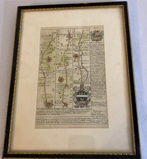
Offered here is a remarkable and likely unique 17th-century English map, dated 1696 and featuring the coat of arms of Baron Haversham, along with intricate details of Oxfordshire and Buckinghamshire. This rare map is attributed to the renowned cartographers John Owen and Emmanuel Bowen, celebrated for their heraldic and historical road maps in early 18th-century England.
The map is divided into three sections, each showing numbered estate plots along roads across Oxfordshire and Buckinghamshire, with precise references to towns such as Haversham and Newport Pagnell. A striking crest of the Thompson family (Baron Haversham) is prominently displayed, accompanied by historical text noting the creation of the barony on May 4th, 1696, during the 8th year of King William III’s reign.
Further down, a detailed note on The Bishopric of Oxford, founded by King Henry VIII in 1541, outlines the ecclesiastical structure and value of the diocese, providing rich context for collectors interested in both political and religious history.
Additional rare elements include:
*
The reference to Robert King, the last Abbot of Osney and first Bishop of Oxford.
*
An early spelling of Newport Pagnell (“NewportPainel”), tracing its origins to Fulke Paynell.
*
A mysterious “BBB” engraving, possibly a printer’s mark or plate reference.
*
What appears to be the coat of arms of the city of Oxford, with symbolic figures and heraldic beasts.
This map is an exceptional piece of British cartographic and noble history, blending landownership, heraldry, and ecclesiastical structure in a single document. A true centerpiece for any collector of early maps, English nobility, or church history.
Condition: As expected for its age, some wear and signs of handling are present, but the text and imagery remain legible and rich with character.
Don’t miss this opportunity to own a documented piece of 17th-century English history connected directly to the creation of a peerage title and the religious reformation era.